Watershed Associations
What can we do for you?
- Provide Interactive Mapping (IM) application
- Delineate areas of interest with borders and/or shading
What can you do with an Interactive Mapping application?
- Insert points of interest (water monitoring, office locations, municipal authorities, superfund sites, known pollutants/polluters)
- Record information and data for points of interest
- Upload photographs for points of interest
- Measure distances
- Track water quality
Example: South Branch Watershed Association
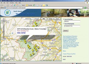
- South Branch Watershed is identified as a green shaded area with a red boundary
- Water monitoring points are identified with yellow arrows
- When monitoring point (arrow) is selected information regarding the site appears
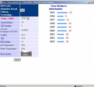
- View detail can show any information collected and recorded which then can be displayed graphically
- Can track changes in data over course of time (years, weeks, seasons)
We can include anything you want and tailor the applications to all of your needs!


